
 Reply With Quote
Here is that spot right as i was mapping it

 Likes: 0
 Thanks: 0
 HaHa: 0
 Crappie Wall Hanger

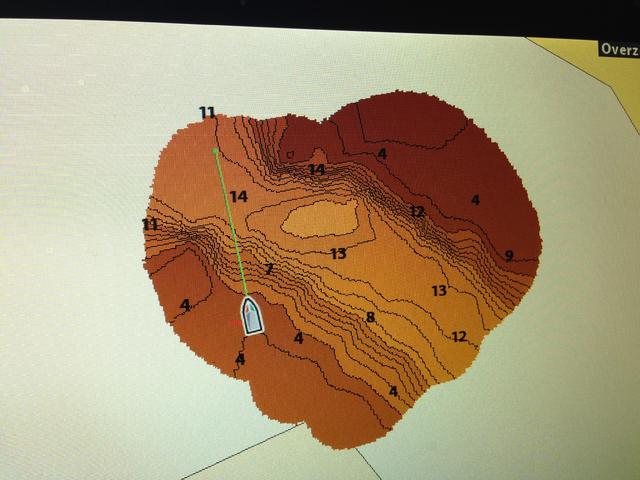
It is pretty awesome. I learned to love side and down imaging but for some reason this might be better. It really explains why the fish are where they are. I had a spot on a river that always produced fish in the winter. I found it by accident and kept going back there using reference points on land to line up with it. Once I mapped it I was amazed at what was down there. A shear ledge dropping from 4 feet to over 10 and then a gentle slope to 15 feet. This 15 foot section was about 20 feet wide by 40 feet long. Just a big depression in a 10 foot flat right off a point. Probably the best spot on the river for a crappie to hide from the cold and current. With my new contour map I can get over it without even trying, so cool.
Crappie Wall Hanger
Crappie.com 3K Star General
ZIPPY,IF IT WAS ME I WOULD NOT WORRY ABOUT THE LITTLE DISTANT FROM DUCER TO UNIT ,I USE MINE ALL THE TIME TO MARK WP AND I CAN GET BACK ON BP THE FIRST TIME NEARLY EVERY TIME,NO NEED FOR A PERFECT WP MARK BECAUSE THE UNIT IS GOING TO BE OFF SOME WITH ANY UNIT.IF U SET ON THE BANK WITH BOAT AND TURN ON UNIT AND TRAIL U WILL SEE YOUR TRAIL MOVE ATLEASE 10 FEET OR MORE.WHEN YOU GO OVER YOUR WP MAKE SURE U ARE GOING STRAIGHT (MOST PEOPLE BIGGEST MISTAKE) AND THE WIDTH OF DUCER WILL PICK IT UP. AFTER U GET GOOD AT GOING TO WP THEN U CAN LEARN HOW TO TURN FROM ONE WP TO ANOTHER WITHOUT GOING STRAIGHT,WHEN USING ARROW TO GET TO WP WHILE TURNING U MUST STOP TURNING BOAT BEFORE ARROW LINES UP WITH TARGET,IT WILL BECOME SECOND NATURE
God Demonstrated his love for us.Romans 5:8
Crappie.com 1K Star General
Sorry, I don't think I was clear enough about the need to have a heading sensor if they were going to offset for mapping purposes.......I was merely trying to point out how complex it would be for them to calculate an offset.Originally Posted by Zippy

I didn't mean to say that the unit WILL calculate that offset ..... They have no accommodation for this in their software. The HS GPS is a very nice thing to have, but it won't help you any with gaining mapping accuracy if the transducer and GPS antenna aren't close to each other.
_______________________________________
Looking for the one that makes it all worthwhile.
Crappie.com 2016 Man of the Year
* Member Sponsor
AutoChart Live is only built in to the HELIX 9, 10, 12, and ONIX ...
AutoChart and AutoChart Pro are Windows based PC software ...which uses Sonar logs to create a map that is then loaded onto a special Zero Lines SD Card and used as a regular LakeMaster map card in the unit ...
If you're not satisfied with the mapping on your home lakes ... Any of the AutoChart products will help you make more accurate maps ...
Rickie
www.podunkideas.com <--Click here
------------
https://www.crappie-gills-n-more.com/
https://cornfieldfishinggear.com/
------------------------>> Pro Staff Sonar Advisor
Crappie.com 3K Star General
No matter how you offset it or what you buy GPS is only accurate within a couple of feet. It all depends on which satellites you are hitting and strength of signal.
Guppy
If you're going to do much mapping, you'll absolutely want to get an external GPS receiver placed as close as practical to the transducer.
Here's why:
When mapping, you're basically gathering hundred of datapoints. Each data point includes Lat,Long, and Depth. AutoChart takes allthose data points, and creates a map from those points.
If your gps receiver is gathering Lat, Long coordinatesthat are 8ft away from your transducer, you automatically have at least thatmuch error in your map.
Now, lets say you're surveing an area in a gridpattern. You go over a drop off one way,and come back over it going the other way, and continue. Your GPS coordinates will be 8ft in front ofyour depth from your transducer going each direction. So, if you were to map a drop off with thissetup, your dropoff would look very uneven, when in fact it might be a straightwall without turns.
The closer your gps receiver is to your transducercollecting depths, the better your map will be.


