 Likes:
  Thanks:
 Reply With Quote
Here are two more images. These are posted outside the forum so maybe this will work.

 HaHa: 0
 Slabmaster II

I thought I read somewhere between oh.....page 5 and page 16 that this unit could not do screenshots? How are you able to take screenshots with yours? That I am interested in! As for the 2gig card, I'll try that. When I selected my source card, I get Lowrance or Navionics as the pull down options. I don't see any difference between the two options so I assumed I needed a Navionics card for the unit to read the card. Navionics software will not recognize any SD card and has to be an actual Navionics card.Originally Posted by crappiepappy

The maps I found were from the Lowrance website. A friend on another forum provided me the link.
Here's the link..
Downloads | Lowrance
I can't remember the exact order of options I found but if you can find the settings to adjust "Overlay Data"....you can select which ones you want. I simply added more data in the list.
I use the unit at the helm of my boat as I have a color Lowrance traditional sonar on my trolling motor. I use the graph and the structure scan to search for structure from the helm. I'd really like to have an HDS 10 up front but that unit costs more than my boat!l want to buy a new bass boat in the next few years and I'll rig it out with the best electronics I can afford. I know a guy locally that relies heavily on side-scan imaging and trolling to find active fish. His catch ratio is unreal.
So here's a question....
I posted only 3 photos. The forum wouldn't let me post any additional photos because it exceeded a quota? Do I get rid of the 3 attachments I have and if I do, will they disappear from my post above? I have two more photos I can post but can't get them to be accepted by the attachment utility. Each file is less than 200kb.
Slabmaster II
Here are two more images. These are posted outside the forum so maybe this will work.
Super Moderator - 2013 Man Of The Year
* Crappie.com Supporter
Screenshots require the following :
Blank 2G micro SD card & reader (this is the one I have ... 2GB microSD Secure Digital TransFlash Card with Reader (BMZ-C) )
Pushing the "Power" button, then the + (MOB) button (per pg 32 of the Operations Manual - http://www.lowrance.com/Root/Lowranc...0153-001_w.pdf ) Also note that it states that screenshots cannot be put on a Navionics Card (which I assume is referring to the Navionics map card)
Being as there is only one card port on a E5DSI ... if you have a map card installed, you would have to remove it & place the blank card in the unit in order to record a screenshot.
************************************************** ************
As to the number of pics in your "quota" .... contact Slab & check on that.
************************************************** ************
I checked your download link. For KY, it only shows two lakes ... one I don't fish, & the other I've fished since it was formed (it's also the one that my base map has the 7/17/27ft contours shown). Hopefully it will be of benefit to other owners.
************************************************** *
And yes ... the source card option is "Lowrance" for the already installed base map -- "Navionics" for the programmed map card from Navionics. But, with that in mind ... I'm wondering if you would also have to change the source card option, when changing out a map card to a blank card in order to take a screenshot ??
... cp
Slabmaster II
For adding additional overlay data, read page 16 of 47 in the electronic PDF version of the operations manual. You can download the manual from Lowrance. The images show how to add overlay data and what your preference is for size of the overlay data.
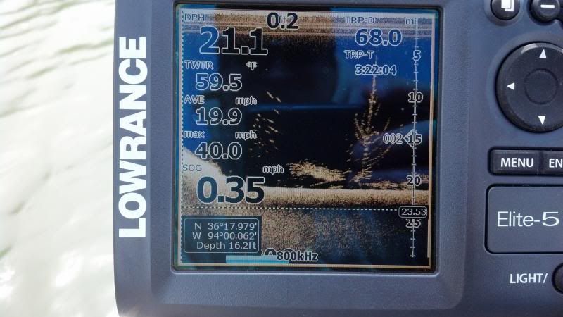
I also use my MAX speed and current speed (COG?) as well as distance to track fuel mileage and at the time, i was breaking in my motor as it was just rebuilt with new pistons, etc. I wanted to track the hours for break in and I was curious as to the max. speed. My old boat is a rare one and it has the original 1979 Evinrude (85hp) outboard on it. The motor is in terrific shape especially after the rebuild. She's a 1979 Cane Cutter 15.2 modified v-hull. It's a heavy little boat and that 85 pushes it pretty good. Hole shot is about 4-5 seconds and if I could get the motor about 1" lower, I think I could increase my max speed but the motor is sitting as low as it will go and it's not worth buying a jack plate for a few mph. Especially when your current WOT is 5,000rpm at 39-40mph.:o
I typically use the 455khz setting when on plane and moving around and change back to 800khz when I am going slow and looking for high detail. The screen is so small I don't prefer the split screen between frequencies.
I want to use the higher defined contour map because I have found spots I didn't know existed due to the higher definition of countours. I have the Navionics app on my phone so I know what the countours are but I'd rather have them on my graph vs. pulling out my phone and using it's battery. The current contours on the graph are almost useless at 10ft intervals. A 1ft drop can make fish hold on a spot. I'd like to know why they are there when I find them on the sonar. Helps put a pattern together.
Slabmaster II
Thanks for the screenshot instructions! I guess I need to read my own manual more! lol!
Slabmaster II
So I got a 2gig micro SD card and it did not allow me to get the higher definition map for my lake. Worth a try.
Also, when I press the power button and then the (+) zoom button trying to take a screenshot, the unit goes off. I have tried to press them at the same time, press the power button and then the other one really quick after pressing power but it shuts off way too easy. REally frustrating. Any thoughts/advice?
Super Moderator - 2013 Man Of The Year
* Crappie.com Supporter
Not sure what the problem is, OA
Are you just pushing on the Power button, then pushing the +/zoom button ... and not holding either one of them in for over a split second ?? I have to hold my Power button in for a second or two, to turn the unit off ... but, if I just bump it, then bump the zoom/+ button, a message comes on screen telling me I've saved a screenshot. As shown in previous posts of this thread, it's worked for me whether the unit was in sim mode or on the water.
Have you tried contacting Lowrance Customer Service ??
Has your unit been updated ? Is it set on Manual or Auto (advanced or default) ?? I don't know if either of these would have any bearing on the situation, but just trying to eliminate any setting differences our units may have.
... cp
Slabmaster II
I'll try again today. I think my powershuts off if iI push the button for one second or more. A standby option comes up sometimes.
I don't remember if the unit is upgraded. How can I upgrade it? I'm pretty sure that's buried in between pages 14 and 30 of this thread! Lol!
I think its in advanced mode. I need to go read up what the difference is between advanced and manual and such. Thank you for the help!
Slabmaster II
Ok so the screenshot works now. Like you said, bump the power button, then the +/zoom button. I was pushing it too long and then I was trying to "push power & push +/zoom" at the same time. That's how I read the instructions. I didn't read it as push and let go and then push the other button! haha!
So, my map is loading on my graph because I can see the historical data for the lake which is really cool. Old cemetaries, an old school, etc. All things that used to be near the river bed before the lake was made back in the late 1950's.
I thought the map I downloaded was the higher definition contours. It may not be. I will call Lowrance and see what the deal is.
Slabmaster II
Oh and I moved my overlay data around to max. my screen for using the sonar. I have depth at (med) text size in the upper left, SOG (mph) at (med) text in the upper right and then everything else is (small) text size and grouped near the bottom corners where you don't see much anyway.


