
Thanks:
0

HaHa:
0
-

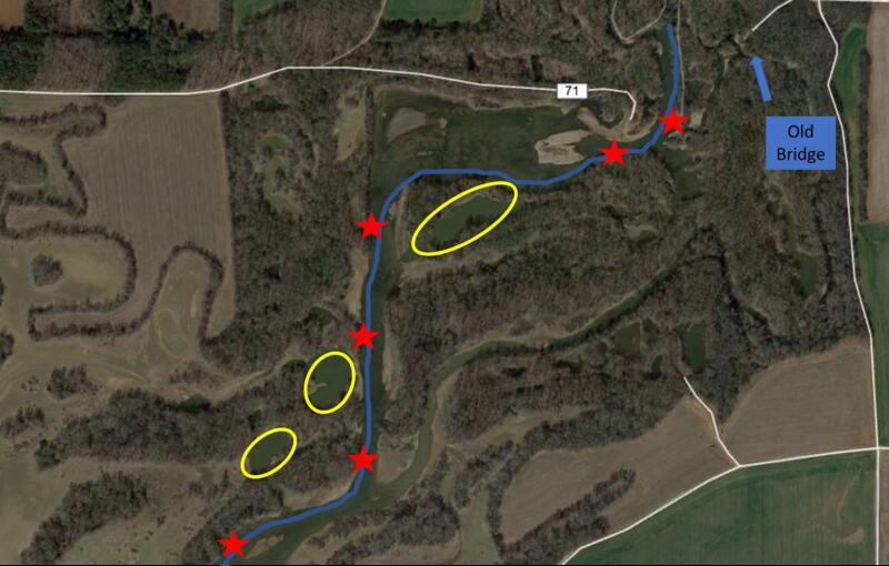
Ok, full disclosure as they say. I usually park at the old bridge and drag/float my kayak to the creek (blue line) during the winter since the gate is closed for closer access.
The red stars are deeper holes that I always fish if I have time and the yellow circles are the three main old gravel pits that I can paddle into off the creek, even during low water. Many of the other pits hold fish, but they can only come in and out during high water. Any area that has 18 to 24 inches of water and a lay down along the creek may hold a couple of fish, so I prospect them tossing a small spinner while moving.
Once the creek turns southwest entering into the bay, there's numerous old stumps on the bottom. This area seems empty of Crappie on many trips, but during low water and low flow you can find them stacked in this area, especially in the spring. I've anchored there many years and caught Crappie until I has tired of taking them off the hook.
I often put in and paddle to the bay, then work my way back to the bridge. That way if I run short on time I'm working back to my vehicle instead of away. The Crappie move around following the bait and often won't be in the same area. One trip they'll be in the deeper holes, next scattered in the pits. I've even found them during low water flow in the middle of the creek hitting shad on the surface in 18 inches of water.
Tags for this Thread
 Posting Permissions
- You may not post new threads
- You may not post replies
- You may not post attachments
- You may not edit your posts
-
Forum Rules
BACK TO TOP

 Likes:


 Reply With Quote


