 Thanks:
  HaHa:
HaHa: 


 Reply With Quote
Good info.
Regards

 Crappie.com 1K Star General

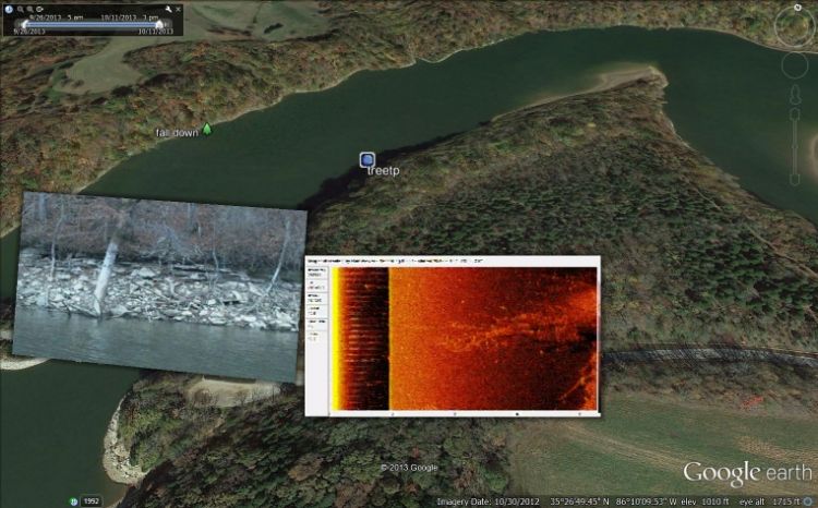
Had a member ask me about using maps and snapshots from SI DI. This IS a very helpful tool for keeping logs or records of locations either when at full pool or draw down on lakes. After setting up the account you can go into it and pull up what ever lake you will be going to.
In the notes you can keep track of the time of year, what worked best ect. The snapshot lets you know what is down there without running over the structure. If you hear they are hitting on standing timber then go to your file of standing timber for that lake and find locations you want to fish that day.
Good tool for those that are interested.
IceNitro LIKED above post
Crappie.com Legend
Good info.
Regards
Crappie.com 2011 Man of the Year
* Crappie.com Supporter
Good. You can also use Google history files to look at the lake at different time intervals. The history file is a great tool. I have made maps of local lakes using google history files and have installed on my HDS (on demand)via SDs.
Crappie.com 3K Star General
Im confused....is this an app?
Crappie.com 1K Star General
Lowe this is google earth. Several ways to use it to help out is fishing, like cane pole spoke of. I use it to store my snapshots of structure and where it is at on the lake.
Crappie.com 3K Star General
So you are accessing google earth to do this through humminbird pc?? Or this regular plain jane google earth? This is very neat! Appreciate you showing this slabbacks!
Crappie.com 1K Star General
Using the lat long you can find the location in GE. When you make your file you can add the snapshot, when you go into that waypoint you can also see the snapshot you added. At one point I had a vid on some of it. If I can find it I will send it to you if you want.
Crappie.com Legend
You can also add all the detail from,Google earth on the lakes you fish to the new units now. Just make sure you only add the detail around the lake. There's instructions online for that. I read it but figured it was over my head.
And as Canepole posted I love the History bottom left on mine. It allows me to see some of the drawdown lakes. With and with out lots of water. Nice to see all the stuff when the lakes are drown down say 30 ft in winter time.. Now to be able to get Google earth in real time.That way you can get a fishing report from home any time anywhere.
Pete


