 Thanks:
  HaHa:
HaHa: 
 Reply With Quote
Please explain.Originally Posted by TNAMBUSHER


 Slabmaster

Just a question. I bought last year and just sold an HB DI unit. I used it on the Chick mostly in shallow water [under 20'] and most of the time in split with the 2D SwitchFire. After using it for awhile I came to the conclusion that, because of the way the DI signal is presented in MOST cases, it is of little added benefit. I had believed when I purchased the unit that it would give me a picture of what was "around" the boat and not just what was under it. In shallow water, that is not the case. It does cover a somewhat wider area than the 2D BUT because it scroll from rt. to lft. like the 2D, objects cannot be pinpointed as to their position relitive to the path of travel. If you scan something that is revealed to be a treetop, stump or brushpile, the only way to know with any certainty where it is, is to run back and forth and scare any fish or fan cast till you make contact. To me, the only way to enhance its usefulness would be to make it function more like SI and scroll from top to bottom. At least that way you could tell the objects position as related to boat path. Just my thoughts and opinion!
Crappie.com 1K Star General
Please explain.
Crappie Wall Hanger II
I need an explanation myself. If that would help you then just mount the screen sideways. Ha
Crappie.com 2K Star General
You can use the formulas on the left side of this picture to help determine at different depths how far out your scanning.also if you don't see something on 2d but you see it on di you no that its out farther than your 2d cone .the best ways to no for sure exactly were an object is,would be si and /360 or sc/spotlight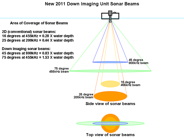
Keeper
I doesn't sound like there is an issue with the unit as you have described it. The principle idea of having DI in addition to 2D sonar is to gain a better understanding of the structure/cover you are seeing on the viewer. The position of the structure/cover relative to your boat could be off by as much as 20 feet depending on your setup. For example: GPS in and of itself can be off by 10 feet or so and if you have the GPS puck, or the unit with built in GPS at the console and your transducer sits at the back of a 20 foot boat, you can add another 10 feet. The more you use the HBUnit, the more confident you will be with how far the distance is between to structure/cover and your boat.
Crappie.com 3K Star General
Down imaging works great for what it's intended for! It's sounds like you are in need of side imaging or 360, but there is nothing wrong with DI. It is intended to be a more detailed compliment to 2D and that's why it sells so well. Some on this site has experimented with DI on a pole mount and the transducer angled so the piezo is able to scan out in front. This may help you accomplish your goal. I assume you are fishing very clear water, if worried about spooking fish in the 20 foot range. In our area we can travel over structure in 10 foot of water easily without spooking the fish.
genec LIKED above post
Slabmaster
My unit did not have GPS. Look at the illustration posted by kos. The DI beam is wide but narrow similar to the SI beam. It achieves its enhanced target resolution by this concentrated beam. Why would it not be better to be able to see this enhanced detail from an overhead perspective. The SI units have Contour View where the "water column" can be removed and you only see the bottom and structure. Why not have the same view from the DI unit BUT just on a narrower scale? That way, you could have the ability to drop a marker on a target that appears 12' to the right of center and do so more accurately.
Crappie.com 3K Star General
A "down" looking transducer cannot distinguish left or right. To determine that, you would almost need two transducers so the unit could then split the two signals the way SI does.
Crappie.com 2K Star General
DI can't do it all. The way I ran my H/B SI unit was start in 2D, if something showed up on the screen I'd switch to DI to determine what it was. Then I'd switch to SI to see if it was under the boat or which side it was off to.
Crappie.com Legend
* Crappie.com Supporter
Does anyone have a 2D/DI split screen snapshot while sitting still?
If so, please post.
USS Intrepid CVS-11 Helicopter Squadron-3 1960-1964
When I keep my gratitude higher than my expectations I have a good day
Posting Permissions


