
Thanks:
0

HaHa:
0
-
 Strange sonar image
I found an orange marker buoy in the middle of the lake, one of those you use to mark a fishing spot; assume that someone forgot it. I cruised around at 3mph to see if it looked like a good crappie spot because that is what it would be in the middle of this lake. There are some logs on the bottom and, shocking to me, what appears to be bream beds! It is quite a large area and winds around on bottom. Bream don't spawn at 28 feet! What the heck is this? If it's not a bream bed, I don't know what it is. And if it is, only thing I can imagine is could it possible the lake was, say, 25 feet lower in the distant past and bream bedded there? This lake is 70 years old. I do not know when it could have been drawn down that far. FWIW, the maximum depth I have found on this lake is 32 feet, not too far from this spot.
On a side note, I have been wondering lately how long a bream bed will look the same. From what I have seen, active beds are well-defined once active. Wonder if they silt over pretty fast. As in months? Have been thinking that active bream beds look crisp, with well-defined honey comb look and with time (months?) that crispness fades due to silt. (I am new to modern sonar side imaging.)
On right side of image below.
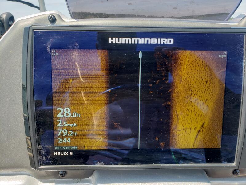
Also, in the water column, those yellow cloudy images, do you think those are fish? They are not arcs like the common fish sonar image. (Humminbird Helix 9.)
~~~
Bill
Tags for this Thread
 Posting Permissions
- You may not post new threads
- You may not post replies
- You may not post attachments
- You may not edit your posts
-
Forum Rules
BACK TO TOP

 Likes:


 Reply With Quote


