HaHa HaHa:  0
Page 2 of 4 FirstFirst 1234 LastLast
Results 11 to 20 of 33

Thread: Side image distance measurements

  1. #11
    rnvinc's Avatar
    rnvinc is offline Crappie.com 2016 Man of the Year * Member Sponsor
    Join Date
    Sep 2008
    Location
    West Ky
    Posts
    13,106
    Post Thanks / Like

    Default


    We cannot visualize the total displayed SI image as 1 dimensional “plane” under the water ...

    This is because the SI image dark water column is more of a geometrical semi-circle (equal to the water depth value) and the bottom detail in the SI image is more of a horizontal plane ...

    So it’s important to separate in our minds how we interpret the dark water column in the SI image with how we interpret the bottom detail in the SI image ...

    Using this representation of the SI image -
    Name:  4F4BB392-55F5-48F5-8851-C0E147583955_zpsku8xnkrn_Original.JPG
Views: 280
Size:  40.9 KB
    Any targets in the magenta color will be “painted” in the SI image dark water column - simply because those targets are closer to the xducer than the actual water depth value (picture in the mind a geometrical semi-circle)

    Any targets farther away from the xducer than the value of the water depth will be painted over the bottom detail in the SI image (picture in the mind 1 horizontal plane) ...

    Rickie
    Last edited by rnvinc; 12-29-2019 at 02:40 PM.
    www.podunkideas.com <--Click here
    ------------
    https://www.crappie-gills-n-more.com/
    https://cornfieldfishinggear.com/

    ------------------------>> Pro Staff Sonar Advisor
    Thanks Heretolearn thanked you for this post

  2. #12
    rnvinc's Avatar
    rnvinc is offline Crappie.com 2016 Man of the Year * Member Sponsor
    Join Date
    Sep 2008
    Location
    West Ky
    Posts
    13,106
    Post Thanks / Like

    Default

    Once we understand that the dark water column in the SI image must be interpreted separately (in our mind) from how we interpret the bottom detail in the SI image (in our mind) ...

    We can see (in the diagram below) that the HB software engineers basically took the left SI image bottom detail and the right SI image bottom detail / and shifted each section of data (left SI and right SI) outward in the displayed SI image to make room in the displayed image for the water column detail ...

    Name:  DBA7A041-BCE7-4632-82EC-64DF4FA14FFC_zpshvtdatvg_Original.JPG
Views: 281
Size:  37.2 KB

    Rickie
    Last edited by rnvinc; 12-29-2019 at 02:41 PM.
    www.podunkideas.com <--Click here
    ------------
    https://www.crappie-gills-n-more.com/
    https://cornfieldfishinggear.com/

    ------------------------>> Pro Staff Sonar Advisor
    Thanks slowhand thanked you for this post

  3. #13
    Join Date
    Mar 2006
    Location
    West Tennessee
    Posts
    1,594
    Post Thanks / Like

    Default

    The drawing explains one thing to me I had wrong. I wondered why when I went by trees that were above water and on the edge of my SI range , only show as stumps

    I had in my mind the opposite of what in the picture above shows.

    This is what I thought I was seeing

    Name:  IMG_0667.jpg
Views: 274
Size:  26.1 KB


    Sent from my iPhone using Tapatalk

  4. #14
    rnvinc's Avatar
    rnvinc is offline Crappie.com 2016 Man of the Year * Member Sponsor
    Join Date
    Sep 2008
    Location
    West Ky
    Posts
    13,106
    Post Thanks / Like

    Default

    Quote Originally Posted by tcounty View Post
    The drawing explains one thing to me I had wrong. I wondered why when I went by trees that were above water and on the edge of my SI range , only show as stumps

    I had in my mind the opposite of what in the picture above shows.

    This is what I thought I was seeing

    Name:  IMG_0667.jpg
Views: 274
Size:  26.1 KB
    Unfortunately the HB diagrams on the web leave a little to be desired in fully explaining what is actually in the SI image ...

    Rickie
    www.podunkideas.com <--Click here
    ------------
    https://www.crappie-gills-n-more.com/
    https://cornfieldfishinggear.com/

    ------------------------>> Pro Staff Sonar Advisor

  5. #15
    Join Date
    Jan 2014
    Location
    Brandon, Mississippi
    Posts
    357
    Post Thanks / Like

    Default

    Quote Originally Posted by rnvinc View Post
    Once we understand that the dark water column in the SI image must be interpreted separately (in our mind) from how we interpret the bottom detail in the SI image (in our mind) ...

    We can see (in the diagram below) that the HB software engineers basically took the left SI image bottom detail and the right SI image bottom detail / and shifted each section of data (left SI and right SI) outward in the displayed SI image to make room in the displayed image for the water column detail ...

    Name:  DBA7A041-BCE7-4632-82EC-64DF4FA14FFC_zpshvtdatvg_Original.JPG
Views: 281
Size:  37.2 KB

    Rickie
    So.....if the bottom image ( directly under the boat) is shifted out so that it displays to the rh or lh side of the water column (black area) the side image measurements at the top of the display are off by the depth of the water?

    Would the cursor measurement be the same as the top scale?

    I noticed from some videos that the side image measurement scale at the top of the display does not change as the boat moves through various depths.


    Sent from my iPad using Tapatalk

  6. #16
    rnvinc's Avatar
    rnvinc is offline Crappie.com 2016 Man of the Year * Member Sponsor
    Join Date
    Sep 2008
    Location
    West Ky
    Posts
    13,106
    Post Thanks / Like

    Default

    Now that we understand that the bottom detail is shifted outward left and right in the SI image to make room for the dark water column in the SI image ... we can explain what actually happens to the bottom detail in the SI image ...

    Below we see two HB SI images - of the very same bottom detail ...:
    Name:  D316BFA2-0BFA-4727-B82A-AB7EF0DC9B31_zpsozwjn4xg_Original.JPG
Views: 242
Size:  95.9 KB

    *The top half is regular SI with the dark water column displayed ...
    *The bottom half is SI with HB ‘s “Contour Mode” on - which basically removes the dark water column ...and correctly represents the bottom detail from directly under the boat outward to the user set SI Range selection ...

    Notice the individual green marks I have drawn on specific details showing on the lake bottom in both SI images ... and how those specific bottom details are “shifted” (some outward and some inward) when the dark water column is inserted into the SI image ...

    The SI Range is not different in the 2 representations - the bottom details at each edge of the screen remain the same ...

    But all the other details in the bottom detail are “compressed” to make room in the displayed SI image for the dark water column section ...

    This “compression” of the bottom details in the SI image (when the dark water column is displayed) - and the fact that SI Range is “slant range distance - not horizontal distance ... is why the SI Range numbers at the top of the screen should only be used as estimates of distance to targets seen on the bottom detail ...

    And the “compression” of the bottom details is also why waypoints marked away from the boat in the SI image cannot be accurate ... and should be re-marked with 2d ...

    There is way more going on in the SI image than simple distance from point A to point B ...

    Rickie
    www.podunkideas.com <--Click here
    ------------
    https://www.crappie-gills-n-more.com/
    https://cornfieldfishinggear.com/

    ------------------------>> Pro Staff Sonar Advisor
    Thanks RustyJig thanked you for this post

  7. #17
    Join Date
    Jan 2014
    Location
    Brandon, Mississippi
    Posts
    357
    Post Thanks / Like

    Default

    Quote Originally Posted by rnvinc View Post
    Now that we understand that the bottom detail is shifted outward left and right in the SI image to make room for the dark water column in the SI image ... we can explain what actually happens to the bottom detail in the SI image ...

    Below we see two HB SI images - of the very same bottom detail ...:
    Name:  D316BFA2-0BFA-4727-B82A-AB7EF0DC9B31_zpsozwjn4xg_Original.JPG
Views: 242
Size:  95.9 KB

    *The top half is regular SI with the dark water column displayed ...
    *The bottom half is SI with HB ‘s “Contour Mode” on - which basically removes the dark water column ...and correctly represents the bottom detail from directly under the boat outward to the user set SI Range selection ...

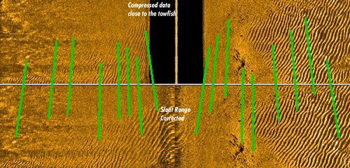
    Notice the individual green marks I have drawn on specific details showing on the lake bottom and how those specific bottom details are “shifted” outward when the dark water column is inserted into the SI image ...

    The SI Range is not different in the 2 representations - the bottom details at each edge of the screen remain the same ...

    But all the other details in the bottom detail are “compressed” outward to make room in the displayed SI image for the dark water column section ...

    This “compression” of the bottom details in the SI image (when the dark water column is displayed) - and the fact that SI Range is “slant range distance - not horizontal distance ... is why the SI Range numbers at the top of the screen should only be used as estimates of distance to targets seen on the bottom detail ...

    And the “compression” of the bottom details is also why waypoints marked away from the boat in the SI image cannot be accurate ... and should be re-marked with 2d ...

    Rickie
    Thanks...makes sense now


    Sent from my iPhone using Tapatalk

  8. #18
    Join Date
    Mar 2011
    Location
    MS
    Posts
    1,329
    Post Thanks / Like

    Default

    The deeper the water the wider your transducers cone.
    Quote Originally Posted by RustyJig View Post
    I was watching a fellow on YouTube, who seemed very knowable, give a class on side image distance measurements and how to determine where a brush pile, stump, etc. is from your boat and he demonstrated it by placing his boat in a parking lot and towing a cooler out to the side and behind his trailer. He proceeded to show how the fish finder displayed this objects distance from the transducer. Everything was clear to my understanding until he said that if the object showed 25 ft to the side of the boat and that you were in 10 ft of water then the object is physically only 15 ft to the side of the boat. He said the transducer shoots a beam to the bottom and then to the side and you must deduct the depth from the displayed distance displayed.

    This would have to be taken into account if you threw a marker bouy for instance. But, he said if you use the mark button on the fish finder it would mark the correct spot.

    Is that correct?


    Sent from my iPad using Tapatalk
    Sent from my SM-G960U using Crappie.com Fishing mobile app

  9. #19
    Join Date
    Mar 2011
    Location
    MS
    Posts
    1,329
    Post Thanks / Like

    Default

    come. Agree mind control salesmanship.
    Quote Originally Posted by Snubby View Post
    I rely on SI to show me fish, structure etc. I then turn to DI or 2D sonar to confirm the depth of what I have discovered and marked by further examination. SI is a valuable tool, but with out down sonar or down image technology it's almost rendered useless in my opinion.

    Sent from my SM-G892A using Tapatalk
    Sent from my SM-G960U using Crappie.com Fishing mobile app

  10. #20
    Join Date
    Mar 2011
    Location
    MS
    Posts
    1,329
    Post Thanks / Like

    Default

    I agree 100% the key is a marked fish. Then an immediate seek visit before they swim 50 yes. Remember what Paw said they ain't no fence around them. Constant movements guaranteed when all the electric pulses push down the water colum.
    Quote Originally Posted by eagle 1 View Post
    It is really simple to me . Some say they can not know exactly where the fish are on the screen . I just run curser over and mark fish as a way point then go investigate . Works for me . lol the distance set in 1/4 increments also set on 40 ft helps .
    Sent from my SM-G960U using Crappie.com Fishing mobile app

Page 2 of 4 FirstFirst 1234 LastLast

Tags for this Thread

Posting Permissions

  • You may not post new threads
  • You may not post replies
  • You may not post attachments
  • You may not edit your posts
  •  

BACK TO TOP