
 Reply With Quote
skip that shows the contour of the bottom....I can clearly see that....but where are the fish....or is that like an overlaying screen?

 Likes: 0
 Thanks: 0
 HaHa: 0
 Super Moderator

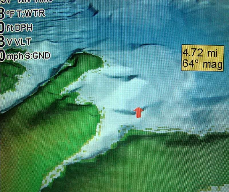
You have two options and this one is what thy call classroom. I left the pic a little bigger because the smaller you make it the worse the lines show up. It is zoomed out a bit.
Skip
Peak Vise Dealer
Tying Materials, Chenille and Hackle
For Pictures of my Crystal, Nylon/Rayon or
New Age Chenille Please PM Me! Also I
have the Saltwater Neck Hackle and some
colors of Marabou plus other things!
Crappie.com Legend
* Crappie.com Supporter
skip that shows the contour of the bottom....I can clearly see that....but where are the fish....or is that like an overlaying screen?
Super Moderator
This is a GPS option on this map and it's is just like a contour map, but with a 3D vied instead of lines. To see the fish you would need the sonar screen up which you can do with split screen or by it self.Originally Posted by poppop

Just think of it as a map and not sonar. Usually a creek or channel showing on one of the HD maps is represented by just a line on the screen among all the other lines that are contour lines. or old roads, what ever. This lest you see the creek/river in a 3D view showing both sides of the creeks and any humps or ridges.
It will allow you to be much more accurate finding creek bends or which bank you want or just staying in the creek. It will let you tell what you are going over easier. It is in no way sonar so you will never see the fish on this part.
As for overlaying, you can also overlay this with top down photos & panoramic lake pictures. Have not got into that yet.
Skip
Last edited by skiptomylu; 06-09-2008 at 09:53 AM.
Peak Vise Dealer
Tying Materials, Chenille and Hackle
For Pictures of my Crystal, Nylon/Rayon or
New Age Chenille Please PM Me! Also I
have the Saltwater Neck Hackle and some
colors of Marabou plus other things!
Crappie.com 1K Star General
thats cool!
Reel foot yankee
Crappie.com 1K Star General
Waay cool!
Crappie.com Legend
* Crappie.com Supporter
good deal..thanks for the explanation
Super Moderator
Your welcome and I am seeing things I never knew were there even with the contour maps. If you look a little more than half way up on this pic there is a ridge and never looked at it before. The water around that is about 40' deep so I will need to check out that ridge to see what it looks like.
Skip
Peak Vise Dealer
Tying Materials, Chenille and Hackle
For Pictures of my Crystal, Nylon/Rayon or
New Age Chenille Please PM Me! Also I
have the Saltwater Neck Hackle and some
colors of Marabou plus other things!
Crappie.com 1K Star General
Im pretty sure you said this, just wanting to be clear. This will not work in ponds or rivers that are not on the map card right? This is basically a map like you said that was done by the core or private company then loaded onto a card and you buy the card...am I right?
Super Moderator
Absolutely and not all lakes on this chip have this ability. You can find out if the lakes you fish have this or not by going to Navionics web site and looking at the platinum lake maps and what lakes have the HD and 3D. The ones I believe in red are the ones with 3D and not sure about the HD since I already had one of them. I am sure they say though. They update these maps ever year and if you find something wrong on them you can send in the info and they will change it for the next year.
I think most of the info comes from either Topo maps from before the lake was filled in conjunction with soundings taken in person by someone. Lots of these lakes have had people go out and just take sounding or sonar readings to make the info for the maps.
Skip
Peak Vise Dealer
Tying Materials, Chenille and Hackle
For Pictures of my Crystal, Nylon/Rayon or
New Age Chenille Please PM Me! Also I
have the Saltwater Neck Hackle and some
colors of Marabou plus other things!
Crappie.com 1K Star General
cool, thanks
Posting Permissions