Reply With Quote
Best way, Mark your way point, then move to other side and Mark again. Try to mark it from 2-3 boat positions. Then try to get right on top of it with DI or 2d and Mark it again. Then name or number the last one you Mark.

 HaHa: 0
 Crappie Wall Hanger II

I have a Humminbird 999 and a Helix 7. I know how to mark waypoints. I know to go to the waypoint on the screen to get to the general area, but I need to know how to return to the EXACT spot that I marked such as a single submerged tree or other small points. Any insight is appreciated.
I may be getting older but I refuse to grow up.
Crappie.com 2019 Man of Year, Supermod & Moderator of the Mechanics Forum
* Crappie.com Supporter
Best way, Mark your way point, then move to other side and Mark again. Try to mark it from 2-3 boat positions. Then try to get right on top of it with DI or 2d and Mark it again. Then name or number the last one you Mark.
Proud Member of Team Geezer
Charlie Weaver USN/ENC 1965-1979
Super Moderator - 2013 Man Of The Year
* Crappie.com Supporter
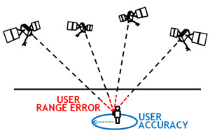
The United States government currently claims 4 meter RMS (7.8 meter 95% Confidence Interval) horizontal accuracy for civilian (SPS) GPS. Vertical accuracy is worse. Mind you, that's the minimum. Some devices/locations reliably (95% of the time or better) can get 3 meter accuracy.
So, the "best" possible outcome is within ~10ft of your waypoint (with civilian GPS units)
That's what makes single point waypoint marks (on small objects) so hard to return to by GPS alone. But, if you do pass over it with 2d or DI and throw out a marker buoy to both sides ... you won't have to keep trying to find it with your depth finder while fishing it.
You also have to remember that your depth finders are not 100% dead accurate, either. 2d & DI will both only show you how far an object is from the transducer, and you have to consider the cone angle (2d) and the angle of the DI fan shaped ping (which depends on which kHz setting you're on), plus the fact that neither one tells you which side of the transducer the object is on ... it just tells you that the object is within the area of the ping shape of whichever mode is being used.

scrat LIKED above post
waterdog101 thanked you for this post
Trophy King II
Mark your point as accurately as possible in the first place. Use maximum zoom and drive straight at the mark, when close watch your sonar and throw bouy well behind when you see the mark. Try to go with the wind when doing this so the bouy will be upwind from you when fishing. Zoom is your friend. The high end antennas are also worth considering and work very well. I run a point one on my big boat but just the standard built in ones on my smaller boats.
Last edited by Flint; 11-20-2017 at 06:46 PM.
Crappie.com 3K Star General
* Crappie.com Supporter
From a space guy...well said. GPS provides a spherical error of probability (SEP). The more "fixes" (marks/wapoints with your GPS) you have on one desired location the more you can reduce the SEP providing a more accurate location. For example, if you mark the same location three times try for the center of those three waypoints. The more waypoints created for one location, greater accuracy can be achieved by predicting the center of all.Originally Posted by CrappiePappy

Triton 190FS, 200hp Optimax, HB 798C HD & War Eagle 548LDV, HiTek, 30hp Mercury, HB 998C HD
Fishing is a privilege...catching is a bonus. Enjoy each precious moment we have to experience our great outdoors!
Crappie.com Legend - Kids Corner Moderator
I have a Helix 10 SI on my trolling motor . I set unit on map 70 % is on 100' scale and 30 % is on 10' scale on preset button . When it pops up on map 10' scale go to another preset button where it has map 30 % on 10' scale and 70 % set on side imaging set out 40' each side . Finding them a piece of cake . It has built in GPS antenna But it makes easier to stay on it with a external GPS antenna with heading sensor (compass )
Moderator of Beginners n Mentoring forum
Takeum Jigs
Crappie.com Legend
Subscribing to thread.....
Crappie.com 3K Star General
* Crappie.com Supporter
Be careful what you ask for. I might have to lay out the "theorem on radical center" to explain. Simple way of remembering is the CEP/SEP location is on the surface and at the GPS or GPS puck, not necessarily the transducer unless one has a GPS puck located near the transducer. The ~10' error is normally close enough for most and within the margin of where fish will be.
If you choose to mark the location with several waypoints, think of it as a Venn diagram and work the center. Have fun.
Triton 190FS, 200hp Optimax, HB 798C HD & War Eagle 548LDV, HiTek, 30hp Mercury, HB 998C HD
Fishing is a privilege...catching is a bonus. Enjoy each precious moment we have to experience our great outdoors!