Thanks Thanks:  0
HaHa HaHa:  0
Page 2 of 5 FirstFirst 12345 LastLast
Results 11 to 20 of 42

Thread: Locating structure / fish

  1. #11
    Join Date
    Mar 2013
    Location
    Hot Springs, Arkansas
    Posts
    742
    Post Thanks / Like

    Default


    I used to live up there and fished El Dorado a lot. This was a long time ago, not long after the lake opened.

    But out I can tell you the first place I would try if I went back tomorrow.

    Launch from the ramp on the west side, the one by the sailboat marina.

    Go go across the lake, and up towards the turnpike.

    Look on a lake map for an old railroad bed that goes out into the lake. It runs straight as an arrow so you should be able to stay on the RR bed pretty easy.

    there is a place where the railroad crossed a creek, so there is a big drop off. I think they took down the bridge before the lake filled.

    I have eave literally caught hundreds of fish right there, of all kinds. This was in a boat with no locator and no trolling motor. What I have now would have only been a dream back then.

    I'm sure the trees that I remember are gone by now, but the structure will still be there. And there isn't a lot of other structure there that I remember.
    Tracker Panfish 16

    Bonafide EX123 Kayak
    Likes IceNitro LIKED above post

  2. #12
    Join Date
    Feb 2016
    Location
    Kansas
    Posts
    75
    Post Thanks / Like

    Default

    Quote Originally Posted by warhawk View Post
    I used to live up there and fished El Dorado a lot. This was a long time ago, not long after the lake opened.

    But out I can tell you the first place I would try if I went back tomorrow.

    Launch from the ramp on the west side, the one by the sailboat marina.

    Go go across the lake, and up towards the turnpike.

    Look on a lake map for an old railroad bed that goes out into the lake. It runs straight as an arrow so you should be able to stay on the RR bed pretty easy.

    there is a place where the railroad crossed a creek, so there is a big drop off. I think they took down the bridge before the lake filled.

    I have eave literally caught hundreds of fish right there, of all kinds. This was in a boat with no locator and no trolling motor. What I have now would have only been a dream back then.

    I'm sure the trees that I remember are gone by now, but the structure will still be there. And there isn't a lot of other structure there that I remember.

    Warhawk, Thanks for the reply.
    I have that spot marked just spent most of my last day out on that spot. In the channel is 40ft.the ledge is about 30 i think. Still lots of trees and the boats usually go through that area to get from one end to the other. I'm not positive i was directly over the old bridge area though. A couple boats trolled through and said they saw alot of fish in the channel as i did. Had maybe 2 bites but not sure what i was actually seeing. I drifted around and anchored to a tree. As afar as can tell the tree line follows the channel. And there are more trees out there than you can shake a stick it,,,pun intended...
    The pic i posted above is not far from that ramp.
    Dev

  3. #13
    Join Date
    Mar 2013
    Location
    Hot Springs, Arkansas
    Posts
    742
    Post Thanks / Like

    Default

    Quote Originally Posted by Slowboat View Post
    Warhawk, Thanks for the reply.
    I have that spot marked just spent most of my last day out on that spot. In the channel is 40ft.the ledge is about 30 i think. Still lots of trees and the boats usually go through that area to get from one end to the other. I'm not positive i was directly over the old bridge area though. A couple boats trolled through and said they saw alot of fish in the channel as i did. Had maybe 2 bites but not sure what i was actually seeing. I drifted around and anchored to a tree. As afar as can tell the tree line follows the channel. And there are more trees out there than you can shake a stick it,,,pun intended...
    The pic i posted above is not far from that ramp.
    It used to be very obvious as there was a tree line on either side of the RR tracks. We caught a lot of fish trolling thru there too.
    Tracker Panfish 16

    Bonafide EX123 Kayak

  4. #14
    CrappiePappy's Avatar
    CrappiePappy is offline Super Moderator - 2013 Man Of The Year * Crappie.com Supporter
    Join Date
    Apr 2004
    Location
    Lexington, KY
    Posts
    23,565
    Post Thanks / Like

    Default

    Quote Originally Posted by fishervet View Post
    Can the 2d sonar images come from any part of the fan shaped span as well? i.e. one side or the other?
    2d sonar is cone shaped ... and yes, it can pick up images from any portion of the cone. It works the same as DI, just a different shape of sonar ping output.

    ... cp
    Likes fishervet LIKED above post

  5. #15
    CrappiePappy's Avatar
    CrappiePappy is offline Super Moderator - 2013 Man Of The Year * Crappie.com Supporter
    Join Date
    Apr 2004
    Location
    Lexington, KY
    Posts
    23,565
    Post Thanks / Like

    Default

    Quote Originally Posted by Slow Retrieve View Post
    If you used your cursor to mark what you see and wish to be the way point wouldn't this avoid this being an issue, or am I understanding that wrong?
    Since you're putting your cursor on the image on the screen, and the GPS antenna's location is where the satellites lock onto ... if the actual cover is out to the side of the boat, but is still within the fan shaped sonar ping of your DI ... you're not getting a pinpoint location of the cover. You're actually getting the waypoint coordinates of the antenna's location (at the surface).

    At least that's the way I understand it.

    ... cp

  6. #16
    CrappiePappy's Avatar
    CrappiePappy is offline Super Moderator - 2013 Man Of The Year * Crappie.com Supporter
    Join Date
    Apr 2004
    Location
    Lexington, KY
    Posts
    23,565
    Post Thanks / Like

    Default

    Quote Originally Posted by Slowboat View Post
    Are there any other sources for structure locations?
    Yep .... GOOGLE EARTH !! But, you may have to use the "history" link to get images of the lake when the water is down. You can then pick out stumps, stake beds, standing & downed trees, and irregular features along the exposed shoreline ... put your cursor on them & write down the coordinates, then manually enter them into your unit.

    I've done this for quite a few spots on a lake I fish, but haven't been to that lake, yet, to test out the accuracy of my work.

    ... cp
    Likes Slowboat LIKED above post

  7. #17
    CrappiePappy's Avatar
    CrappiePappy is offline Super Moderator - 2013 Man Of The Year * Crappie.com Supporter
    Join Date
    Apr 2004
    Location
    Lexington, KY
    Posts
    23,565
    Post Thanks / Like

    Default

    Quote Originally Posted by Slowboat View Post
    I believe the 2d beam is cone shaped and not as wide as the DI. The strong returns in the 2d beam would be more centered in the beam and weaker returns would be more to the edge. You just don't know which edge. Front.back,left or right.
    The DI beam is wider but very thin so the returns can be strong throughout the beam but again you cannot tell if it is centered or left or right.
    It seems like changing to a higher frequencies would narrow the beams so most returns would be closer to the boat.
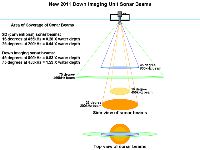
    Also the depth will change how wide the beam is covering the bottom. 10fow not much coverage, 30fow 3 times more coverage. According to my HB manual a 83khz 60 degree beam coverage is equal to your depth.
    These charts may give you a better perspective :


    And your statement about the 60deg 2d beam being equal to the depth is also correct. A 20deg angle beam gives a bottom circle of about 1/3 the depth of the water ... so 3 times that angle would give a bottom circle diameter more or less equal to the depth of the water.

    ... cp

    (chart images taken from my thread on the Lowrance Elite 5 DSI, that's in the Electronics Forum)

  8. #18
    Join Date
    Jan 2014
    Location
    Kentucky
    Posts
    267
    Post Thanks / Like

    Default

    Quote Originally Posted by CrappiePappy View Post
    Since you're putting your cursor on the image on the screen, and the GPS antenna's location is where the satellites lock onto ... if the actual cover is out to the side of the boat, but is still within the fan shaped sonar ping of your DI ... you're not getting a pinpoint location of the cover. You're actually getting the waypoint coordinates of the antenna's location (at the surface).

    At least that's the way I understand it.

    ... cp
    I didn't realize that. So if I am understanding correctly, essentially there is no real benefit to marking a way point using the cursor on the screen instead of simply marking the boats current position? Why even have the feature?

  9. #19
    Join Date
    Feb 2016
    Location
    Kansas
    Posts
    75
    Post Thanks / Like

    Default

    Quote Originally Posted by Slow Retrieve View Post
    I didn't realize that. So if I am understanding correctly, essentially there is no real benefit to marking a way point using the cursor on the screen instead of simply marking the boats current position? Why even have the feature?
    The benefit on the sonar is that everything you see is history. Meaning you have already passed anything showing on the screen. So if something is on the left side of your screen it could be 20,30,50 yards back depending on your speed. The cursor allows you to make the coordinates at that point in history. So at any point on your screen moving the cursor will show you the coordinates at that point when you you actually went over it.
    Some good unit maybe even records even more than what's on the screen at that particular time.
    Dev

  10. #20
    Join Date
    Feb 2016
    Location
    Kansas
    Posts
    75
    Post Thanks / Like

    Default

    Quote Originally Posted by CrappiePappy View Post
    These charts may give you a better perspective :

    And your statement about the 60deg 2d beam being equal to the depth is also correct. A 20deg angle beam gives a bottom circle of about 1/3 the depth of the water ... so 3 times that angle would give a bottom circle diameter more or less equal to the depth of the water.

    ... cp

    (chart images taken from my thread on the Lowrance Elite 5 DSI, that's in the Electronics Forum)

    thanks again CP.
    i have not seen that DI coverage chart before.
    And I will check out the history on google earth. Haven't played with it much since I got it recently.
    Thanks for the great info!
    Dev

Page 2 of 5 FirstFirst 12345 LastLast

Tags for this Thread

Posting Permissions

  • You may not post new threads
  • You may not post replies
  • You may not post attachments
  • You may not edit your posts
  •  

BACK TO TOP