Thanks Thanks:  0
HaHa HaHa:  0
Page 1 of 4 1234 LastLast
Results 1 to 10 of 38

Thread: OK WMA Maps, Coordinates unconfirmed

  1. #1
    Join Date
    Jul 2005
    Location
    Oologah, Oklahoma
    Posts
    6,242
    Post Thanks / Like

    Default OK WMA Maps, Coordinates unconfirmed


    Thanks to new board member isnms, ( you should really choose a name, tough to remember yours and jrfwmf) for sending us the Great link to Oklahoma Wildlife Managment Topo Maps. The site states the coordinates that I was looking at were unconfirmed, but, it should be close enough to pinpoint hotspots to those visiting the forum. I don't have a GPS yet, but hope to someday. Now, there are those fisherman out there that dare not ever share a spot. I have no problem with it, as everytime I clean the area out of the keepers, more appear by next trip. It's just like magic. Areas of Talala Creek that I was destroying the 2-3lb fish during spawn, would have a new fish in place by the time I was ready to "make the rounds again". If I would have been fishing the CAST Championship, I might have won with the fish I caught by myself that day.
    Anyway, for those of you who DO have a GPS on their boat, I would be more than happy to show you a few places I frequent on Oologah. I had experienced a 6 week lull without a single keeper, then, wham, started finding hot spots that still are fairly consistent.
    Reaper

    http://maps.scigis.com/odwc/MapFrame.asp
    Last edited by Crappie Reaper; 08-30-2005 at 07:25 PM. Reason: add link OK wma
    Reaper, Where Fish come to Fry

  2. #2
    Join Date
    Aug 2005
    Posts
    30
    Post Thanks / Like

    Default

    I'm not good at names. If I'd have had a third kid, I'd have named him/her Three.
    Hard time with passwords too.

    I sent you a PM, hope you don't mind. I took you a little deeper into the site than I intended. Back up a notch after you've investigated to see prior years and tell me if this is something worthwhile.

  3. #3
    Join Date
    Aug 2005
    Location
    Oklahoma
    Posts
    124
    Post Thanks / Like

    Default ODWC Data Viewer

    haha, yeah, my user name doesn't make anything you can pronounce. it's my title at work - Information Systems Network Management Specialist -

    Edited this post with the new url.

    Digital Wildlife Management Areas Atlas
    http://www.wildlifedepartment.com/wmas2.htm

    on the site: http://fishlab.ou.edu/odwcims/ -
    once you zoom into the lake you're interested in, you can use the tools on the right to show different views.
    use:
    Recreational Layers - to show Lakes with fish data and ODWC fish attractors
    Imagery - to show Aerial photos(1995), Color aerial photos(2003), USGS Quads and 3D Quads (the quads are topo including lake body)
    there are other features on the right
    http://www.wildlifedepartment.com/wmas4.htm

    Tool bar on the left: used for zooming in and out. and I like
    http://www.wildlifedepartment.com/wm...ut_What_the_Sy
    Select by Rectangle This tool allows you define an area and examine all the features of the active layer within that area. With the select by rectangle tool active, draw a rectangle on the map and a small window will appear displaying all the individual items within the rectangle you drew. Identifies them by highlighting in yellow.

    Last edited by isnms; 03-28-2007 at 09:42 AM.
    One More Cast ...
    Likes IceNitro LIKED above post

  4. #4
    Join Date
    Jul 2005
    Location
    Oologah, Oklahoma
    Posts
    6,242
    Post Thanks / Like

    Default

    What great info! Thanks so much again for teaching us. I bet if others in the main forum saw this, they would be jealous.
    The aerial picture of Talala Creek on Oologah is alot clearer than most of the other lake pictures. You can actually see runs of humps in an area that I thought was too shallow. It also shows a brushpile in the same area. I printed it out, and will check it out my next trip.
    The link you just posted about the help section is just great. What an excellent tool for anyone who ventures outdoors to use.
    Reaper
    Last edited by Crappie Reaper; 08-31-2005 at 10:06 AM. Reason: typo
    Reaper, Where Fish come to Fry

  5. #5
    Join Date
    Aug 2005
    Location
    Oklahoma
    Posts
    124
    Post Thanks / Like

    Default

    Thanks for the kind words. I was very excited too when I found it on the wildlifedepartment web site. And the best part, it's FREE
    I have yet to see all that it can do. I've only looked at Draper and Thunderbird since they are the closest to me.
    One More Cast ...

  6. #6
    Join Date
    Aug 2005
    Location
    Oklahoma
    Posts
    124
    Post Thanks / Like

    Default

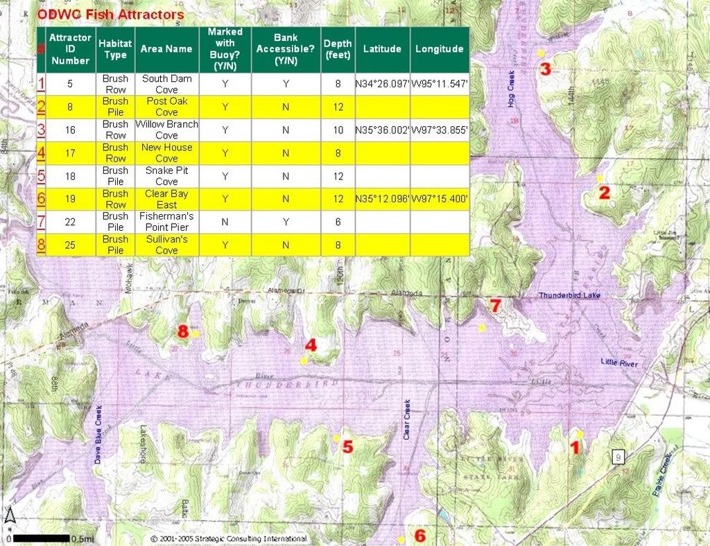
    Number 4 in the above map was very productive Sunday. The three of us must have kept over 90, caught many more but put back the smallest ones.
    I know I cleaned 45 myself.
    One More Cast ...

  7. #7
    Join Date
    Jul 2005
    Location
    Oologah, Oklahoma
    Posts
    6,242
    Post Thanks / Like

    Default

    What lake is that?
    Reaper, Where Fish come to Fry

  8. #8
    Join Date
    Aug 2005
    Posts
    30
    Post Thanks / Like

    Default

    I believe it is Thunderbird. Check the purple print on right hand side behind Hog Creek label.

    One could locate a Geographic Name Server and search for Hog Creek in Oklahoma and if listed check out its location(s) to see if in vicinity of Thunderbird.

  9. #9
    Join Date
    Aug 2005
    Posts
    30
    Post Thanks / Like

    Default

    I believe it is Thunderbird. Check the purple print on right hand side behind Hog Creek label.

    One could locate a Geographic Name Server and search for Hog Creek in Oklahoma and if listed check out its location(s) to see if in vicinity of Thunderbird.


    Feature Name
    ID
    Class
    County
    State
    Latitude
    Longitude
    Map
    Ele(Ft)
    BGN
    Entry Date

    Hog Creek
    1093819
    Stream
    Pottawatomie
    OK
    345624N
    0970201W
    Wanette
    945
    -
    18-DEC-1979

    Hog Creek
    1093821
    Stream
    Sequoyah
    OK
    352641N
    0944559W
    Sallisaw
    469
    -
    18-DEC-1979

    Hog Creek
    1093815
    Stream
    Latimer
    OK
    345452N
    0950246W
    Red Oak
    522
    -
    18-DEC-1979

    Hog Creek
    1093818
    Stream
    Pushmataha
    OK
    341007N
    0952233W
    Rattan
    436
    -
    18-DEC-1979

    Hog Creek
    1093816
    Stream
    Grady
    OK
    345641N
    0975717W
    Ninnekah
    1089
    -
    18-DEC-1979

    Hog Creek
    1093823
    Stream
    Cleveland
    OK
    351336N
    0971328W
    Little Axe
    1033
    -
    18-DEC-1979

    Hog Creek
    1093817
    Stream
    Beaver
    OK
    365153N
    1000101W
    Gate
    2136
    -
    18-DEC-1979

    Hog Creek
    1093822
    Stream
    Ellis
    OK
    360224N
    0995438W
    Arnett SW
    2172
    -
    18-DEC-1979

    Hog Creek
    1093820
    Stream
    Caddo
    OK
    350251N
    0981842W
    Anadarko West
    1197
    -
    18-DEC-1979


    That's the counties and quad map names if any are close to Thunderbird.

    Lake Thunderbird is on the Little Ax Quad in Cleveland County from same server.

    Lake Thunderbird
    1100127
    Reservoir
    Cleveland
    OK
    351315N
    0971309W
    Little Axe
    994
    -
    01-JUN-1990

    Lake Thunderbird
    1751091
    Reservoir
    Cleveland
    OK
    351300N
    0971301W
    Little Axe
    1001
    -
    10-JUL-1997

  10. #10
    Join Date
    Aug 2005
    Location
    Oklahoma
    Posts
    124
    Post Thanks / Like

    Default

    Yes it is Thunderbird.


    It was a very fun day
    Last edited by isnms; 08-13-2008 at 08:42 PM.
    One More Cast ...

Page 1 of 4 1234 LastLast

Posting Permissions

  • You may not post new threads
  • You may not post replies
  • You may not post attachments
  • You may not edit your posts
  •  

BACK TO TOP