 Thanks:
  HaHa:
HaHa: 

 Reply With Quote
Wow

 Crappie.com 2011 Man of the Year
* Crappie.com Supporter
Crappie.com 2011 Man of the Year
* Crappie.com Supporter

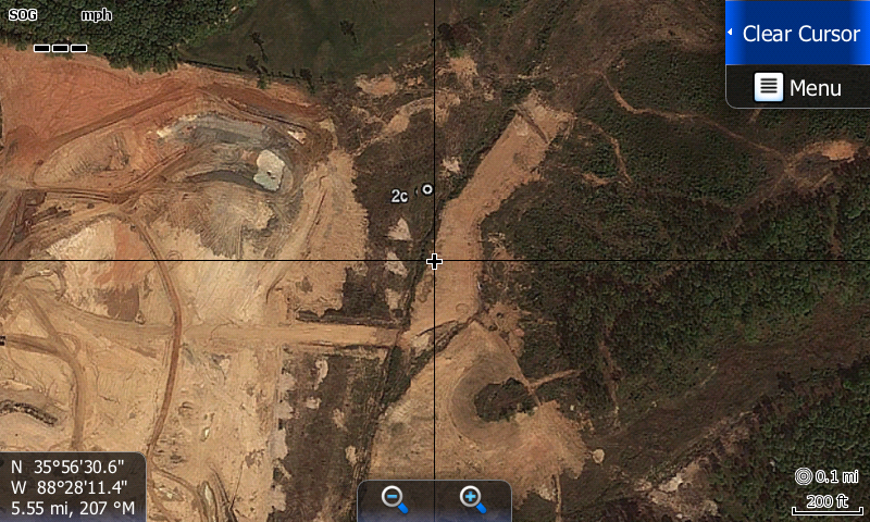
Been fiddling with some mapping for My HDS touchers. I finally cracked the code for my mapping.
This is a overlay map that I generated from OZIEXPLORER . I made a map card sd and walla, I kin view my own map.
This pic is from Google Earth history file and is a snap shot from the history file on Google Earth.
This is the dirt bottom of this new local lake here in Tn. This is what you would be seeing with the
SI/DI stuff.
I am not thru with this map. It is just a sample shot. I will have to calibrate the whole lake at about 600 square foot at a time to have good resolution. Takes time and concentration to git er done.
I am a happy hooker. This is a good project for winter. Keeps me mentally wake and morally straight. I was a good boy scout too. ha
You can see the cross hair is near a feeder ditch to the lake. This is near the dam. I don't care if all see the GPS position either.
You can't find how to do this on Google folks. There is no there there. I had to figure it out.
Member BS Pro-Staff and Billbob Pro-Staff
Proud Member of Team Geezer... authorized by: billbob and "G"blueball LIKED above post
Crappie.com Legend
Wow
CG1 "Dances with fish"
Super Moderator
* Crappie.com Supporter
Cane Pole you never cease to amaze.
The love for fishing is one of the best gifts you can pass along
Crappie.com Legend
Can you share with us how you did that.
Crappie.com 2011 Man of the Year
* Crappie.com Supporter
Wii do when I get to lake and verify the accuracy.
Member BS Pro-Staff and Billbob Pro-Staff
Proud Member of Team Geezer... authorized by: billbob and "G"
Crappie.com 1K Star General
Good job CP.
PROUD MEMBER OF TEAM GEEZER


